I recently went on a two-mile trek to the center of the earth. Okay, not quite the center of the earth but the trail did lead underneath Highway 97 – the main North-South highway in these parts. I decided to visit Lava River Cave before it shut down for the season. This cave is located 12 miles south of Bend, Oregon in the Newberry Volcanic National Monument area.
I heard parking is limited so I arrived early. WAY too early! I forget that I only live a half an hour from many of these geological attractions.
For more information on operating hours and entrance requirements, check here. You must make reservations for timed entry into the cave. Make reservations here.
Set along the scenic Deschutes River, the Art in the High Desertevent features 110 artists from throughout North America. Based on its sales of fine art, it is ranked number 12 for best fine arts festival in the nation. This is the ninth year of the event. The show features a wide variety of two- and three-dimensional artwork.
My favorite works there this year were created by local artist, Jason Waldron. He makes three-dimensional works created with wood and metal scraps salvaged in Central Oregon. They are large, dramatic, and expressive. Check them out at Waldron 3D.
Have you ever finally made it to a place that people had told you you HAD to go to? For me that place was Hosmer Lake. Why didn’t I go here sooner?!
We went early on a mid-weekday morning. I had heard about the crowds sometimes here on weekends. It can get very crowded – especially in the summer.
Bald eagle, Haliaeetus leucocephalus
There is a concrete boat ramp leading into a bulrush-lined meandering lake. After boarding our kayaks, we were soon greeted by a bald eagle perched in a nearby tree. It was almost as if it had been planted there for a photo opportunity. We paddled on and took a channel to the left.
Dee Wright Observatory in the distance from the trail
Dee Wright Observatory, McKenzie Pass, Oregon
Looking like some medieval castle about to be attacked by dragons, the Dee Wright Observatory is located near the top of McKenzie Pass at an elevation of 5,187 feet. No, there is not a telescope set up here for star viewing, but you can see several Cascade Mountain peaks nearby standing tall amidst 65 square miles of black lava rock.
The lava is from relatively recent flows from Yapoah, Little Belknap, and Belknap Craters. One of the types of lava you will see here is called Block or A A lava.
Though there is little rainfall in this area, there can be up to 20 feet of snow. The melting snow travels through cracks in the lava to underground reservoirs that feed the McKenzie and Metolius Rivers.
History of Dee Wright Observatory
The McKenzie Pass Highway follows parts of the McKenzie Salt Springs and Deschutes Wagon Road that was built in the period of 1866-1872. It was used to move cattle east. The wagon road was established as a toll road in 1872. It’s hard to imagine how travelers made it over the rough lava rocks at the pass and many had to abandon their wagons. See my previous post on the Santiam Wagon Road for a little bit more history on the wagon road.
Did you know that you can surf on the Deschutes River? Yes, thanks to the creation of the Bend Whitewater Park you too can hang ten on the river that flows through Bend, Oregon. Maybe you would rather float down in an inner tube – you can do that too. Maybe you want to get a glimpse of some wildlife – that’s also an option. The river was split into three channels: the Habitat Channel for wildlife; the Whitewater Channel for kayaks, surfboards, and stand up paddleboards; and the Passageway Channel for inner tubes and small rafts.
Passageway Channel.
A 100-year old dam was recently removed from the river near the Colorado Avenue Bridge and an “amusement park” was put in by Bend Parks and Recreation. At a cost of nearly $10 million dollars, some questioned its value. Bend Paddle Trail Alliance, one of the local groups in support of this park, contributed over $1 million towards the project. The voter-approved bond said that water recreationists would have “safe passage” once the project was completed. That’s a good idea since people were injured or lost their lives because of the dam.
Life can take a lot of twists and turns so it’s nice to get a bouquet once in a while. This giant size balloon bouquet was my cherry on the top of a great weekend. They were here for the annual Balloons Over Bend event.
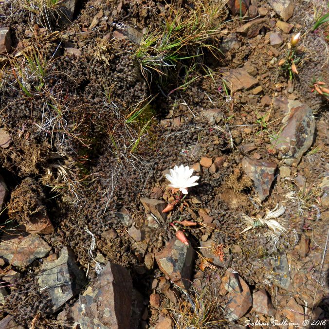
Oasis moments sometimes happen in the desert. While hiking to Chimney Rock near Prineville, Oregon, we came across a patch of bitterroot flowers. The small flowers burst forth from cracks in the sandy soil in shades of pink and white. The flowers are only about an inch and a half across. The plant is delicate yet hardy at the same time.
I had never seen so many blossoms in one place. Bitterroot has always been a plant that amazes me. It was hard for me to keep walking with our group when a part of me just wanted to crouch down to their level and marvel at their perfection.
What Meriwether Lewis wrote about bitterroot
Beneath the soil, a taproot gives this plant its name. Meriwether Lewis, of the Lewis and Clark Expedition, first saw the bitterroot plant in Lemhi County, Montana on August 22, 1805. Lewis tasted the root and described it in his journal:
this the Indians with me informed were always boiled for use. I made the exprement, found that they became perfectly soft by boiling, but had a very bitter taste, which was naucious to my pallate, and I transfered them to the Indians who had eat them heartily.
Baskets & photo of digging stick, Warm Springs Museum
Usage by Native Americans
Bitterroot can be found in much of western North America in drier areas with well-drained gravelly soils and several tribes made use of the plant. Shoshoni, Flathead, Nez Perce, Paiute, Kutenai, and other tribes used digging sticks to collect the roots in the spring. The roots were dried and were often mixed with berries and meat.
The roots were traded and bartered and were considered to be of great value. A bagful was worth as much as a horse. They were used as food but also had medicinal uses. Bitterroot was used for several ailments including heart problems and sore throats. They were also used to treat wounds and to increase milk flow in nursing mothers.
President Thomas Jefferson had asked Lewis to collect plant specimens on their expedition. Bitterroot plants were collected on the return trip in June of 1806. The area in Montana where the plants were collected is now known as the Bitterroot Valley. Specimens were given to the botanist Frederick Pursh in Philadelphia. Pursh named the plant Lewsii redviva in honor of Lewis.
Fun fact: The species name redviva means “reviving from a dry state.” The specimens presented to Pursh came back to life even though they had been dug up many months before.
Tucked away in Oregon’s Outback, you will find a unique place that hearkens back to an earlier time. The Cowboy Dinner Tree is a small restaurant located in Silver Lake Oregon, about an hour and a half southeast of Bend. The restaurant is only open from 4:00-8:30 pm four days per week and reservations are required. They give you ample portions of food here and you are advised to bring a cooler for leftovers. They do not take credit cards or debit cards so have cash on hand.
Steak at Cowboy Dinner Tree
Roasted chicken
You have your choice of a 26-30 oz. top sirloin steak or a whole roasted chicken. Both are accompanied by several tasty side dishes. There is green salad, hearty soup, old fashioned sweet yeast rolls, baked potato, and a dessert. You can have coffee, iced tea, or pink lemonade with your meal. On the day we were there, they served bean soup and a small shortcake with fresh berries. Everything is homemade and made daily.
Last weekend I was out looking for some of the 11+ species of woodpeckers that can be seen near Sisters, Oregon. The Dean Hale Woodpecker Festival brings birdwatchers from all over the world into the woodpecker-rich habitats in the area. East Cascades Audubon Society has been putting on the well-attended event since 2011. There were 17 different field trips this year.
Black Butte & Mt Jefferson, Oregon
It was a hot day and stunning views of the Sisters peaks, Black Butte, and Mt Jefferson welcomed us.
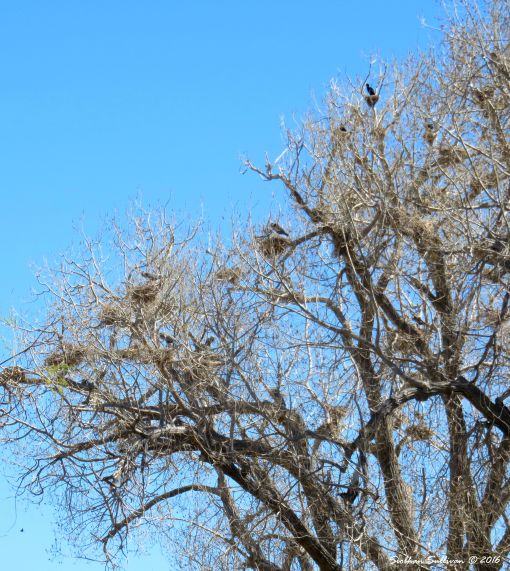
If we learn to focus in on things and look closer, we sometimes find the unexpected.
In this case, it’s a double-crested cormorant and great blue heron rookery. These birds look and act so differently yet they manage to get along.
This rookery is located at the Sod House Ranch at Malheur NWR. It was built by cattle-baron Peter French in the late 1800’s. The ranch was the headquarters of the French-Glenn Livestock Company that at one time covered 140,000 acres.
Maybe Newberry National Volcanic Monument can light its own candles for its 25th birthday celebration. It’s young as a monument and is also young in geological terms.
Big Obsidian Flow
Mordor?
The amazing, and appropriately named, Big Obsidian Flow feature was formed a mere 1,300 years ago. You can walk up a trail that winds through a massive mountain of sparkling obsidian. When I say massive I mean MASSIVE – 380 million cubic yards! From a distance, the landscapes appear to be a real life version of Mordor. Up close, the shimmering reflections all around you are dazzling.
You can get to top of the Lava Butte cinder cone by hopping onto a shuttle or taking a short hike from its base. The 500-foot tall butte is located at the Lava Lands Visitor Center in the Newberry National Volcanic Monument about eight miles south of Bend, Oregon. Lava Butte is one of the hundreds of cinder cones in the immediate area.
Benham Falls trail
Lava Butte erupted about 7,000 years ago. There are several trails that wind through the ancient lava flows and onto the flanks of the butte. There were three main gutters where most of the lava flowed. Ten square miles of pine forest were buried by lava. The lava flows blocked the Deschutes River in five places. If you walk the trail to Benham Falls you can see where the river has made its way through the lava rock.
Thinking about trying out snowshoeing? Last weekend I went out for the first time to try out snowshoeing on Mt Bachelor as part of a free guided tour. Knowledgeable volunteers take you out for a 90-minute walk in a forested area near the ski runs. The tours leave at 10:00 am and 1:30 pm. Snowshoes are provided (thanks to REI for donating them) or you can wear your own.
A snowy Mountain Hemlock forest
The volunteers will give you a quick talk on a few of the dangers associated with this sport such as tree wells. This is the area that forms in the snow close to a tree that people can fall into and sometimes not be able to get out of. I also learned that predators like to go into them in search of entrances to the burrows of small mammals. Kind of like a vending machine area for them.
Last week I took a quick trip to see the sunset from Smith Rock State Park. Sometimes you forget to appreciate what is in your own backyard. I will go back again when I have more time…
Did that get your attention? I went to the Oregon WinterFest event here in Bend this weekend and took some pictures of the Fire Pit Competition that I wanted to share with you. This is the 17th year of the festival so it has a long history in the area. This is the fourth year for the fire pit competition and there are more entries every year.
The dragon and a fire pit with the flag bridge and Deschutes River in the background.
When you go outside into parts of the 135-acre property, you will be able to visit various exhibits. The Autzen Otter area is being renovated and won’t be open again until sometime in the spring of 2016. Be sure to stop by to see the entertaining otters once the exhibit reopens.
Feeding Station
Cooper’s Hawk
Keep going around the trail and make a brief stop at the wildlife viewing area. Here you might get a glimpse of woodpeckers, nuthatches, chickadees, squirrels, and chipmunks. You might get lucky and spot a hawk or owl waiting to get a snack.
The Wind, Earth, and Fire Trail is nearby and it shows how fire plays an important role in forest development. Keep following the trail and stop into the Changing Forests exhibit to learn about forests in the area.
Miller Ranch
Miller Cabin
Looking back in time
Next you will see the Miller Family Ranch. The buildings there are built to show what a farm in 1904 would have looked like. Peek inside the cabin to see how a family lived and watch interpreters demonstrate life in those times. There’s also a barn, corral, chicken coop, saw mill, and even an outhouse. The woven wood corral is practical but also a work of art. You may see horses, donkeys, and chickens at the ranch.
Tucked away in the pines south of Bend, you will find a magical place. The High Desert Museum may not be what you expect when you see the word “Museum” in its name. Yes, it does have artifacts in permanent and rotating exhibits but they are beautifully displayed in buildings that blend into the environment. There is much more to this place than traditional exhibits.
Sage Grouse exhibit
Tough By Nature exhibit
What to see at the High Desert Museum
The rotating exhibits cover many facets of the high desert. In December of 2015, these included one on weather, one on sage grouse, and another on women of the American West. There are daily talks and demonstrations about nature and history related to exhibits at the Museum. The Museum also has people dressed in period clothing interpreting history and a small collection of desert wildlife.
High Desert Ranger Station
One of the first things you see as you drive up the long driveway is the small High Desert Ranger Station. This was an actual station and it was built in 1933 and moved here in the 1980’s. It’s only open during the summer months.
Game of Thrones fans may know what dragonglass is but the rest of you may be going, “Huh?” The rock plays an important role in the story. Most people know it by the name obsidian. Like glass, obsidian fractures into pieces with sharp edges. It can be found in a wide variety of colors.
Obsidian from my yard
Obsidian forms when lava from a volcano cools rapidly with minimal crystal growth. Volcanic activity in Central Oregon is recent, in geological terms, so obsidian is fairly common in some areas. Lava flows covered hundreds of acres in this region. I have found obsidian in my yard between the sagebrush and bunchgrass. Isn’t this a cool piece?
I had to go north to Seattle for a couple days but it’s great to be back to my home on the range. I saw these two does, appropriately, near the town of Antelope, Oregon.
It is easy to see why the Painted Hills are designated as one of Oregon’s Seven Wonders. The Painted Hills Unit of the John Day Fossil Beds National Monument , located nine miles northwest of Mitchell, Oregon, is 3,132 acres in size.
Painted Hills Unit of John Day Fossil Beds National Monument (US National Park Service)
If you visit the Painted Hills after rainstorms move through the area, the colors will look more intense from the recent moisture. The colors are striking no matter what season it is. It is like looking at a parfait of luscious layers spread out before you. The deep crimson and black layers at the base of the hills contrast with the sandy browns and golds of upper layers.
If you drive just a couple of hours east of Bend, Oregon you’ll find strikingly painted hills and a center devoted to paleontology. The Thomas Condon Paleontology Center will impress you with fascinating information and artfully displayed artifacts. Wow! What a place.
The Lava Lands Visitor Center has interpretive exhibits that focus on local volcanology, geology, ecology, and archeology. As I entered the exhibit area, the red “lava flows” in the carpet guided me you through the center. Display boards are big, bright, and bold. They contain A LOT of information.
This small center is a great place to start a visit to the 54,000+ acres of the Newberry National Volcanic Monument near Bend, Oregon. The Monument was created in 1990. It encompasses unique geological features, lava flows, and many lakes.
I recently went on a Deschutes Land Trust hike just west of Bend, OR to learn about fire ecology. The area we hiked in is known as the Skyline Forest. There were fires in this vicinity in 2010 and 2014 and together they burned about 6,000 acres. The area is currently privately owned but the Deschutes Land Trust has been trying to acquire it.
Our guide, Pete Caligiuri with The Nature Conservancy, informed us that this area has about the steepest environmental gradient in the world. In the Cascade Mountains the precipitation can be as high as 160 inches per year while less than 25 miles away, it can be as low as 10 inches per year. Plants respond to the extreme amount of variability in this gradient. In the past, fire and moisture limited the number of trees in the forest. Now there can be as many as 800-900 trees per acre in this area.
Lots of shrubs in the understory
We looked around to see how many large stumps left over from timber harvesting we could see. There weren’t many at all. At one time this forest had the trees much more widely spaced. We noticed the high number of young trees with branches reaching down closer to the ground. There was also a thick growth of underbrush that included bitterbrush and manzanita. The forest floor was covered with pine needles and fallen branches. The closer spacing, higher number of shrubs, and accumulation of litter on the forest floor makes this forest more vulnerable to fire.
Last week I went on a Metolius Preserve hike with the Deschutes Land Trust (DLT). This 1,240 acre preserve is located about ten miles west of Sisters, OR and was acquired by the DLT in 2003.
The forest
Ponderosa pine trees dominate the landscape but there are also Douglas fir, grand fir, incense cedar, and western larch trees. The pine trees near the kiosk are spaced about 30-40 feet apart and bunchgrass forms the dominant ground cover. Though the habitat appears natural, the forest has been restored with the help of Pacific Stewardship. The forest has been thinned and prescribed burns will foster an old-growth type of habitat. They have even created snags so that some of the 13 types of woodpeckers that live here find a good place to feed and nest. DLT also planted bunchgrass.
The year is 1905 and you have traveled thousands of miles across the country. You spot a fort-shaped rock formation in the distance and know you are finally close to your destination. A sage thrasher perched atop sagebrush seems to be singing its melodic song to welcome you. As you draw closer, you see several buildings clustered around a windmill-driven well. The wind blows the desert dust into your eyes. Blinking to make sure it’s not a mirage; you can’t help but let out a sigh of relief. You made it – you are finally here.
Fort Rock Homestead Village Museum
Though that account was fictional, it would be easy to imagine that kind of scenario as you tour Fort Rock Attractions. The Fort Rock Valley Historical Society Homestead Village Museum site currently contains 12 buildings from the early 1900’s that were moved to the site from various locations in Central Oregon. There is a small gift store with items related to the area at the entrance. A replica blacksmith shop was constructed at the site in 2006 using reclaimed wood and other materials. Volunteers restored the buildings and carefully furnished them with artifacts. Due to their painstaking work, you really get a feel for how the early pioneers lived.
You will be impressed by the attention to detail. Buildings represent what would have been present in a small town of that time period. For example, the small doctor’s office appears ready to accept the next patient.
A walk along the mile-long trail of the Lava Cast Forest gives you a glimpse of how recent volcanic activity has affected the local environment. The trail is located several miles directly west of Sunriver, Oregon in part of the Newberry National Volcanic Monument.
The Warm Springs Museum, located in Warm Springs, Oregon, is impressive inside and out. As you approach the building, note the interesting architecture that echoes some of the structures local tribes lived in. Be sure to view the building from the back as well. The building honors the Wasco, Warm Springs, and Northern Paiute tribes that reside in the Warm Springs Reservation area. There is a ¼ mile long interpretive trail behind the Museum.
Historically, the Paiute lived in a large area of Southeastern Oregon and traveled far in search of food. The Wascoes, or “river people”, lived east of The Dalles along the Columbia River and were primarily fishermen. The Warm Springs people lived in a large area in the vicinity of the current reservation. They moved between summer and winter villages and were more dependent on game, roots, and berries. There was a lot of trading that went on between the tribes for food and other resources.
Baskets & photo of digging, Warm Springs Musem
Tribes looked to their elders for guidance and passed on traditions to their children. The family was the center of learning. Children learned subsistence skills such as basket making and hunting but also learned the value of traits such as patience and commitment.
Each tribe chose their own chief. They respected the values and traditions of other tribes. For example, the seven drum religion of the Wasco was shared with other local tribes.
Europeans enter the scene
When white men entered the scene in the 1700’s, the importance of trade increased. Coffee, sugar, cloth, and especially beads, were valued trade items. Unfortunately the settlers also brought diseases that native people had very little immunity to. By the time Lewis and Clark arrived in 1804, the numbers of Native Americans had plummeted due to many succumbing to various diseases.
Exploration of the area by early settlers continued into the 1800’s. The Indian Removal Act was approved in 1830. In the 1840’s immigrants began moving to the area on the Oregon Trail. From 1840 to 1860, 250,000 settlers traversed the Oregon Trail. John C. Fremont explored the area that would become the Warm Springs Reservation in 1843.
Forced onto reservations
In 1855 Native Americans were forced onto reservations. Most of their ancestral lands were ceded to the U.S. The Wasco and Warm Springs tribes ceded ten million acres.
The Northern Paiutes fought against scouts, soldiers, settlers, and other tribes in an attempt to keep their lands. They were finally defeated by General George Crook between 1866 to 1868 and forced on to the reservation.
The tribes were forced to give up their culture. Certain traditions were outlawed. Children were forced to attend boarding schools. If they were caught speaking their native language they were given demerits.
Preserving a past
The Warm Springs Museum preserves part of the past and passes on valuable information to future generations. A short film on the history of local Native Americans plays as you enter the exhibit hall. You learn that water was important to all tribes and was referred to as the “blood of life”.
As you make your way through the Museum you will see an impressive collection of artifacts and recreations that give you a glimpse into the various tribes’ way of life. Many of the items are decorated with tiny seed beads that show an amazing amount of detail and artistry. Belts, bags, buckskin clothing, and war bonnets all feature intricate beadwork.
Re-creations of a wickiup and tule mat lodge invite visitors to look inside the structures local Native Americans lived in. A small, rustic cabin stands nearby. Tools of daily life are visible inside the structures.
There are a few parts of the exhibit that are interactive. A camera films you as you attempt to use a hoop and copy the moves playing in a video of the hoop dance. Another display features recordings of the languages of the three tribes living on the reservation.
A nice gift store
The small gift store is a great place to browse for local products. There are several books on regional topics. Jewelry, bags, and colorful prints are also available. Huckleberry jam and syrup are tempting to buy for yourself or as a gift for someone else. Boldly patterned Pendleton blankets are neatly tucked into shelves patiently waiting for someone to wrap themselves in their warmth.
If you are interested in the history of the Central Oregon area, consider a stop at the Warm Springs Museum. It is nicely laid out and has some remarkable artifacts in its collection. The information provided with the displays is interesting and may pique your curiosity into learning more. That is always a sign of a great museum.
A fluttering of wings draws my eyes. An unknown call turns my head. Finding birds and figuring out what they are is like working as an investigative detective. You notice things that don’t fit into the puzzle that forms the background environment. I’m no expert but I look for clues such as the silhouette, size, markings, behavior, and sound. Apps such as iBird and various field guides help you narrow down the list of possible suspects when you are out birding. Sometimes you know what something is right away; other times you need to confer with others. There are times when you have only a fleeting glimpse so then you might refer to the bird as an LBJ – Little Brown Jobbie.
Mountain Bluebird
Birding in the High Desert
Though Bend is located in a desert environment, there is no shortage in the number and variety of birds that live here. We are fortunate that there are so many organizations involved in educating visitors and residents about the wealth of feathered creatures in the area. I have been on birding walks with the High Desert Museum, East Cascades Audubon Society, Sunriver Nature Center, and Deschutes Land Trust. People who go on the walks range from novice to very experienced birders.
Sharp-shinned Hawk
Many of the guided walks have one thing in common – water. Even in my own yard a water feature attracts birds like some super powerful magnet. Lakes, rivers, ponds, and even small backyard water features, draw birds in.
I see a rainbow of birds in my backyard from the comfort of my La-Z-Boy recliner. The constant flurry of activity includes the brilliant blue of mountain bluebirds, yellow of lesser goldfinches, red of Cassin’s finch, impossibly smooth tannish-brown and butter yellow of cedar waxwings, and soft gray of mourning and Eurasian collared-doves. A sharp-shinned hawk occasionally comes in for a quick meal. I also get to see unusual visitors such as leucistic American robins and dark-eyed juncos. Leucistic birds have plumage that is partially white and they really catch your eye.
Deschutes County has a wide variety of habitats ranging from high elevation mountains with alpine plant communities to lower elevation sagebrush steppe. You might see gray-crowned rosy finches on the way up South Sister or sage grouse on a lek at lower elevations near Millican. Several websites list birds you are likely to see at various locations. The Birding Oregon site has some detailed information on where to go. Here is the Deschutes County link http://birdingoregon.info/Home/DeschutesCounty/tabid/168/Default.aspx .
If you are looking for an interesting historical area to visit close to Bend, try following parts of the route of the Santiam Wagon Road. It parallels present day Highway 20 and parts of Highway 126 between the cities of Sisters and Lebanon, Oregon. This particular wagon road is interesting because its purpose was to provide safe passage from the Willamette Valley eastwards into central Oregon. A route was found in 1859 by connecting old Native American trails to a route discovered by Hudson’s Bay Company trapper, Thomas McKay. It became the main route across the Central Cascades from 1865 to 1939. In 1939 the Santiam Highway opened.
The road was maintained by the Willamette Valley and Cascade Mountain Wagon Road. Local ranchers formed the company with Andrew Wiley, John Gray, and John Brandenburg. These pioneers originally proposed the road and scouted a route. Tolls were collected along the route. Settlers used the road to move their livestock eastwards to pasture lands and markets. The new road also enabled trade, commerce, and communication between areas East and West of the Cascades.
Why, you may be asking, is she writing about beer on a site that is supposed to be related to history and nature. Well… beer is a big part of Bend’s history.
Deschutes Brewery Black Butte Porter and a growler
The history of beer in Central Oregon
Earlier this year, the High Desert Museum had a great exhibit about brewing. It was a temporary exhibit and it has closed but I can still share part of what I wrote about the exhibit. Here is an excerpt:
“The exhibit follows the history of brewing with an emphasis on activity in the Central Oregon region. What started out as saloons set up in tents has evolved into brewpubs that can be found throughout the area. Brewing slowed down during the Prohibition period of 1920 to 1933. Prohibition actually started four years earlier in Oregon due to the protests from some of its residents. Many women that participated in the temperance movement were upset by the bad influence alcohol had on their lives. At one time, there were breweries in nearly every Central Oregon town.
After Prohibition ended, new businesses opened that served a wide variety of alcoholic beverages. Grant’s Brewery Pub located in Yakima, Washington, was the first craft brewery in the northwest. It opened in 1982. In 1983, after a series of legislative measures passed it became legal to produce and sell beer from independent breweries in Oregon. Craft brewing started in Bend in 1988 when Gary Fish opened Deschutes Brewery. As craft beer became more widely accepted, other breweries opened in two successive waves of activity that began in the 1990s. There are currently 26 breweries in the area with five more rumored to be opening in the not too distant future. Continue reading →
Skeleton Cave – the name immediately brings questions to your mind. The designation refers to the discovery of several animal skeletons found inside of the cave. This lava tube cave is located south of Bend off of the China Hat Road (also known as Road 18). Incidentally, 690 caves have been discovered in Deschutes County and 577 of them are lava tubes.
Inside Skeleton Cave
There is currently a metal staircase leading down into the cave. In the past it was just like a large pit trap that animals sometimes fell into and then could not escape. Because of this, skeletons and fossilized remains of several species of animals have been found within the cave. These included horse, deer, elk, bear, fox, a large hyena-type canid, lynx, a small carnivore, and various rodents. The horse skeleton found in the cave was determined to be that of Equus niobrarensis. It lived during the Pleistocene era that ended 10,000 years ago.
The cave was discovered in 1924, although writing on the cave wall indicates it may have been visited in 1894. An old still was found in the cave. It was surveyed by Walter T. Perry and Phil Brogan. They measured the main cave at 3,036 feet long with a side passage of 1,734 feet. Later, in 1971 Jim Neiland measured the cave more accurately at a length of 3,560 feet.
Lava tube cave
Lava tubes are tunnels that form when slow moving lava develops a hard exterior crust that thickens as the interior, faster flowing, lava continues to flow through until it drains away.
On the ceiling of Skeleton Cave you can see “lavacicles” which are a variety of stalactites. They form as the lava drips from the roof of a cave and cools and hardens.
This cave is especially popular with visitors and many have enjoyed exploring it. The temperature inside the cave averages 43 degrees Fahrenheit. Visitors can walk into the first part of the cave and explore deeper sections by climbing and crawling.